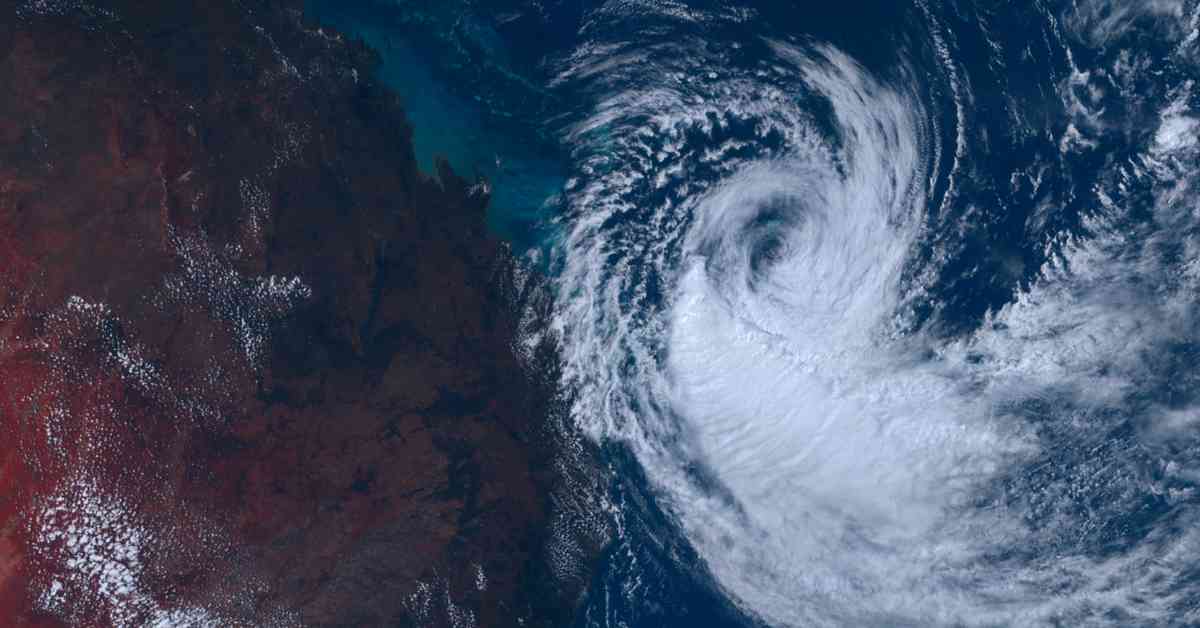
As residents in northern NSW brace for the impending arrival of Tropical Cyclone Alfred, the region is on high alert for what could be the first tropical cyclone in over three decades. The cyclone is projected to make landfall sometime on Thursday, prompting officials to issue cyclone warnings from Bundaberg South to Grafton, just south of Yamba and Byron Bay.
The Bureau of Meteorology’s Manager of hazard preparedness, Steven Bernasconi, highlighted the significance of this weather event by drawing parallels to the impactful cyclones of the past. He recalled the landslides and mass evacuations caused by Cyclone Zoe in 1974, emphasizing the potential for similar devastation with Cyclone Alfred’s arrival. Bernasconi stressed the rarity of such events in NSW, underscoring the need for heightened preparedness among residents.
In a bid to enhance community readiness, the Hazards Near Me app has been flagged as a crucial tool for residents to download. Meanwhile, SES Flood rescue crews are already on standby in anticipation of the cyclone’s impact. With projections indicating that Alfred could intensify to a category two cyclone, packing 100km/h winds, waves exceeding eight meters, and up to 300mm of rainfall, authorities are urging residents to stay vigilant and make necessary preparations.
Unprecedented Threat: A Rare Cyclone for NSW
While cyclones are relatively uncommon in the northeast corner of NSW, the impending arrival of Tropical Cyclone Alfred is sending ripples of concern through the region. The last cyclone to hit NSW was Nancy in 1990, underscoring the historic nature of this weather event. With forecasts predicting widespread heavy rain from late Wednesday into the weekend, residents are bracing for potentially severe flooding and coastal inundation.
Steven Bernasconi emphasized the familiarity of the region with severe weather events like east coast lows, which can yield similar impacts to tropical cyclones. However, the unique threat posed by Alfred’s triple threat of strong winds, massive waves, and heavy rainfall has stirred a sense of urgency among residents and authorities alike. Coastal river catchments are on high alert for moderate to major flooding, with the risk exacerbated by already saturated grounds and high tides.
Community Response and Preparedness
As communities across northern NSW gear up for the looming cyclone, lifeguards in tourist hotspot Byron Bay have already taken precautionary measures by closing all beaches. The sight of white water swallowing the shorelines serves as a stark reminder of the impending storm’s power. Lifeguard Scott McCarthy described waves reaching up to eight feet, a testament to the force of nature that residents are bracing for.
In the face of this unprecedented weather event, authorities are urging residents to stay informed and prepared. The 9NEWS app is highlighted as a valuable resource to stay updated on the latest developments and safety advisories. With the region on high alert and emergency response teams on standby, the community is rallying together to weather the storm and mitigate potential risks.
As Tropical Cyclone Alfred inches closer to the NSW coast, the region stands at a critical juncture, poised for a weather event that could leave a lasting impact. With memories of past cyclones and the specter of severe flooding looming large, residents are heeding the warnings and taking proactive steps to safeguard their homes and loved ones. In the face of uncertainty, the resilience and unity of northern NSW communities shine through, underscoring the collective strength in the face of nature’s fury.


